31 March 2014: Gibraltar

By Corey Sandler, Silversea Destination Consultant

Gibraltar is one of the planet’s odd corners, also one of the most recognizable pieces of geology: The Rock.

B-GIBRALTAR 31Mar2014 _DSC0004

Silver Wind approaches the dock at Gibraltar. Photo by Corey Sandler

It has a quirky mix of cultures: a British territory clinging to the bottom of the Iberian Peninsula of Spain. To some eyes, the last remaining colony in Europe.[whohit]-31MAR2014 GIBRALTAR-[/whohit]

There a few other places of this sort, including Spain’s exclaves of Melilla and Ceuta on the Moroccan coast not far away. We’re headed to Melilla soon.

B-GIB1

The Rock, from the rock next door. Photo by Corey Sandler

The Strait of Gibraltar is the only natural gap between the Med and the world’s oceans. At its narrowest, the Strait of Gibraltar is only about 13 kilometers (8 miles) wide.

Scientists say about 5 million years ago the two continents were connected here. The Mediterranean Sea was more like a huge lake, and had evaporated into a deep basin much lower than the oceans.

Gibraltar is a very small place: 2.6 square miles or 6.8 square kilometers. About two New York Central Parks, or three Monacos.

The base of the rock is home to about 30,000 people, one of the world’s most densely populated cities.

B-GIBRALTAR 31Mar2014 _DSC0010 B-GIBRALTAR 31Mar2014 _DSC0012

Streets and alleys at the base of the Rock in Gibraltar. Photos by Corey Sandler

The narrow isthmus ends at Spain. The Gibraltarians and the British call it a frontier; the Spanish call it a fence.

In Greek mythology, Hercules had to perform 12 labors to please the gods. The tenth labor—the westernmost assignment—took place here.

Hercules had to cross the massive Atlas mountain in North Africa, on his way to the Garden of the Hesperides. Instead of climbing Atlas, Hercules smashed through it by tearing down a pair of mountainous pillars.

The two points marked the limit to the known world. By his action, Hercules opened the Strait of Gibraltar, connecting the Mediterranean to the Atlantic.

B-GIB3

The extraordinarily strange airport at Gibraltar. Windston Churchill Avenue crosses the runway, and cars and other vehicles are stopped at a barrier to allow planes to land or take off. Photo by Corey Sandler

One of the pillars was Gibraltar. The other, in various versions, could have been Monte Hacho which overlooks the Spanish exclave of Ceuta in Morocco.

The other suspect: Jabal Musa (Mount Moses) in Morocco.

Where was Hesperides? Some place it in what is now Libya.

Others say the Garden of Hesperides was on Gran Canaria in the Canary Islands, where our voyage began.

It was across this gap that the Moors—the Muslim tribes—came across to Europe in 711, surrendering al-Andalus in 1491.

In 1501 Gibraltar passed back to the Spanish Crown: Ferdinand II of Aragon and Isabella I of Castile.

We jump forward to 1704, when Spain’s great empire was crumbling.

An Anglo-Dutch force captured Gibraltar during the War of the Spanish Succession.

And then it was made official—at least to the current satisfaction of the British. In 1713, Gibraltar was ceded to Britain by Spain under the Treaty of Utrecht.

Spain attempted to retake Gibraltar in 1727 and again in 1779, when it entered the American Revolutionary War on the American (or at least the anti-British) side as an ally of France.

Spain helped finance the American effort, and fought against the British in Spanish Louisiana and Central America.

But back in Europe, the Great Siege of Gibraltar was the first and longest Spanish action in the war, from June 24, 1779, to February 7, 1783.

The Franco-Spanish army was as large as 100,000, greatly outnumbering the British. But the British were able to hold out in the fortress. The Rock became an important base for the British Royal Navy.

B-GIB-4

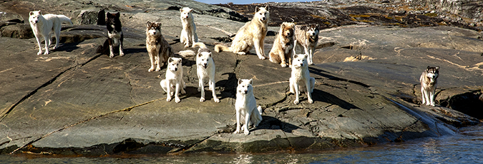
Notable residents of The Rock. Photo by Corey Sandler

It played a role in the Battle of Trafalgar, Nelson’s victory against the combined fleets of the French and Spanish in 1805.

Its strategic value increased with the opening of the Suez Canal in 1869 as it controlled the sea route between the UK and the British Empire east of Suez.

B-GIBRALTAR 31Mar2014 _DSC0007

The Courts of Justice in Gibraltar. Photo by Corey Sandler

Spanish dictator Generalisimo Francisco Franco was no saint; not even close.

But he did not trust Hitler, a feeling that was mutual.

Franco’s reluctance to allow the German Army onto Spanish soil frustrated a German plan to capture The Rock.

The detailed plan for Operation Felix was ready to go, but on March 10, 1941 Hitler instead launched Operation Barbarossa—the invasion of its one-time ally the Soviet Union.

Operation Felix was delayed and ultimately abandoned.

Although it was bombed several times and suffered other privations, the Rock came through the War relatively unscathed.

Inside the Rock of Gibraltar, miles of tunnels were excavated from the limestone. By some measures, there are more miles of road within the Rock than outside.

All photos copyright 2014 by Corey Sandler. If you would like to purchase a copy, please contact the author.
 

29 and 30 March, 2014: Casablanca and Rabat, Morocco

By Corey Sandler, Silversea Destination Consultant

After visits to the islands of Cape Verde, the Canaries, and Madeira, we move back now to mainland Africa: Casablanca in Morocco. And some of us went on a side trip to Rabat, the capital.

From our ship, or from any high point on land, it’s easy to see at a glance the geographic relationship between northern Morocco and Spain.[whohit]-29 and 30MAR2014 AGADIR and CASABLANCA-[/whohit]

The two continents were bridged by land as recently as 5.3 million years ago, a few moments in geological time.

Today only about 9 miles or 14 kilometers separate Africa from Europe.

B-RABAT MOROCCO 30Mar2014 _DSC0001

A Gnawa musician inside the Kasbah at Rabat. Gnawa is a stirring form of music with a strong rhythm; its roots are in Ghana but nearly the only place it is played is in Morocco. Some believe it gave birth to jazz. Photo by Corey Sandler

Morocco has a population of about 35 million, about the same as Canada.

And you won’t hear this sentence all that often: Morocco and Canada are similar in another context.

The vast majority of the population of Morocco live within about one hundred miles of the coast; in Canada, nearly all of the population is that far from the border with the United States.

Morocco, though, is much smaller.

Only about 172,410 square miles; Canada is 22 times larger.

Casablanca is the largest city and principal port; Rabat is the national capital.

B-RABAT MOROCCO 30Mar2014 _DSC9935

The King’s Palace in Rabat. Photo by Corey Sandler

When World War II began, North Africa quickly fell under control of Axis powers. Italy moved first, into Ethiopia.

Germany dispatched Field Marshal Erwin Rommel—the Desert Fox—and his Afrikacorps Panzers and they had initial victories in Egypt, Libya, and Tunisia.

And Morocco—a French protectorate—came under the collaborationist Vichy French.

That was the environment under which Rick Blaine (or Humphrey Bogart, if you prefer) operated Rick’s Café Américain in Casablanca.

The Allies pushed back in late 1942.

It was decided it was too soon to launch a cross-channel attack from England to France. The British pushed for a second front: against Axis forces in Africa, in what was called Operation Torch.

In addition to forces from the United Kingdom, Operation Torch was the first major operation by Americans.

They sailed directly from the United States, the only instance in World War II where a significant force was loaded in American ports and landed directly on a hostile beach.

The Allies achieved strategic surprise, but the operation was delayed by French forces, who fought back in many locations including Morocco.

Why? French Vichy troops were told by the Germans there would be retribution in France if they failed to fight off the Allied invasion.

But French opposition ended in November. And some 275,000 Germans and Italians surrendered on the Cape Bon Peninsula in Tunisia on May 12, 1943.

B-RABAT MOROCCO 30Mar2014 _DSC9980 B-RABAT MOROCCO 30Mar2014 _DSC9978 B-RABAT MOROCCO 30Mar2014 _DSC9969 B-RABAT MOROCCO 30Mar2014 _DSC9970

The Mausoleum of Mohammed V in Rabat. Mohammed VI, his grandson, is now on the throne. Photos by Corey Sandler

Once Morocco was under Allied control, it became an important base for air raids on Sicily and France, and also crucial in controlling the choke point of the Strait of Gibraltar.

Before, during, and after World War II, Moroccans did not much like their French overseers. They were denied freedom of speech, assembly, and travel.

Just as happened in other colonies—including Algeria—a nationalist movement rose in Morocco.

On March 2, 1956, after forty-four years of occupation, the Kingdom of Morocco gained independence from France and Spain.

B-CASABLANCA MOROCCO 29Mar2014 _DSC9905 B-CASABLANCA MOROCCO 29Mar2014 _DSC9910

Inside the ancient Medina of Casablanca, which bears no resemblance to a Tesco or a Safeway or most any other place most of us shop. At right, the apparent losers of camel races, ready for roasting. Photos by Corey Sandler

B-CASABLANCA MOROCCO 29Mar2014 _DSC9927 B-CASABLANCA MOROCCO 29Mar2014 _DSC9925

Haute couture in the Medina of Casablanca. Photos by Corey Sandler

Spain held on to the Spanish Sahara, to the south and west, until the death of Francisco Franco in 1975. Today that territory is still uncertain.

What is now called the Western Sahara is considered by the United Nations to be a non-self-governing territory.

That is the same status given by the UN to Gibraltar.

B-CASABLANCA MOROCCO 29Mar2014 _DSC9929

Not-so-haute cuisine in Casablanca. Do they know his name is Colonel Sanders? Photos by Corey Sandler

Now available, the revised Second Edition of “Henry Hudson Dreams and Obsession” by Corey Sandler, for the Amazon Kindle. You can read the book on a Kindle device, or in a Kindle App on your computer, laptop, tablet, or smartphone.

Here’s where to order a copy for immediate delivery:

http://www.amazon.com/dp/B00IA9QTBM

Henry Hudson Dreams cover

Henry Hudson Dreams and Obsession: The Tragic Legacy of the New World’s Least Understood Explorer  (Kindle Edition)


26-27 March 2014: Funchal, Madeira

By Corey Sandler, Silversea Cruise Consultant

The Portuguese island of Madeira has beautiful beaches, spectacular mountains, abundant sun, a moderate climate, a toboggan ride with no need of ice or snow, and an airport that makes many pilots reconsider their occupation.

Madeira is part of an archipelago in the north Atlantic Ocean about 522 kilometers or 326 miles north of the Canary Islands.[whohit]-26MAR2014 FUNCHAL MADEIRA-[/whohit]

The archipelago comprises the major part of one of the two Autonomous regions of Portugal; the other is the Azores to the northwest.

FUNCHAL MADEIRA 26-27Mar2014 _DSC9847 FUNCHAL MADEIRA 26-27Mar2014 _DSC9845

Downtown Funchal, as flowers burst into color for the oncoming Spring. Photos by Corey Sandler

Today, Madeira is a popular year-round resort, drawing about one million tourists per year.

Madeira is currently ranked the second wealthiest region in Portugal, after Lisbon, with a GDP per capita of 104 percent of the European average.

FUNCHAL MADEIRA 26-27Mar2014 _DSC9843 FUNCHAL MADEIRA 26-27Mar2014 _DSC9835

The Cathedral of Funchal, and the main shopping and dining street. Photos by Corey Sandler

Even before the great expeditions began to use Madeira as a stopping-off point on their way to the New World, it was used in commerce to and from Europe.

Among the sailors who used it as a base was Christopher Columbus who lived for a while with his first wife and child on the lesser island of Porto Santo in Madeira.

As Portugal, and by extension, Madeira began to grow in wealth the island attracted attacks by pirates and privateers. And we’re not just talking about small freelancers.

FUNCHAL MADEIRA 26-27Mar2014 _DSC9879

Terraced farms high in the hills. Some of the farms grow grapes for sweet Madeira wine. Photo by Corey Sandler

In September of 1566 French corsairs under the command of Bertrand de Montluc departed from Bordeaux with a force of 1200 men, on three main ships and eight support craft. The corsairs landed on Madeira and marched toward Funchal and laid siege to the city, which eventually fell.

The following year, the Portuguese decided to install a better defense, including fortresses and other installations. Better protected, Funchal became an important stop-over for caravels travelling between the Indies and the New World.

FUNCHAL MADEIRA 26-27Mar2014 _DSC9869 FUNCHAL MADEIRA 26-27Mar2014 _DSC9861

Up in the hills above Funchal, a dramatic landscape with roads not for the faint-of-heart. Photos by Corey Sandler

Just as an aside, in February of 1815, one of the great naval battles of the War of 1812 took place just off the coast of Madeira. The War of 1812 was essentially a re-ignition of the Revolutionary War fought between the American colonies and Great Britain.

The USS Constitution, one of the first ships of the U.S. Navy and now better known by her nickname of Old Ironsides engaged two smaller British ships, the HMS Cyane and HMS Levant. The American vessel carried 52 guns and 451 men and crippled both British vessels.

None of the three captains had any way of knowing that the War of 1812 had ended three days earlier.

After his wartime service as Prime Minister and before returning to office in 1951, Winston Churchill discovered Madeira for himself. He favored a small fishing village called Câmara de Lobos—Wolf’s Den—about 5 kilometers or 3 miles from Funchal, as a place to paint.

FUNCHAL MADEIRA 26-27Mar2014 _DSC9896

Camara de Lobos, a favorite setting for painting by Britain’s Winston Churchill. Photo by Corey Sandler

The town has a lovely bay surrounded by banana plantations, vineyards, and other vegetation on the hills. And Churchill generally chose to stay at a hotel called Reid’s Palace. The atmosphere at Reid’s has changed little since the hotel opened in 1891, even though it is now part of the Orient-Express Hotels chain.

If you arrive by boat, as Churchill did for his visit in 1950, a lift carries you up from the hotel’s private bathing pier. In the hotel lobby you can see old photos of British and European elite who came to visit.

FUNCHAL MADEIRA 26-27Mar2014 _DSC9888

Sea cliffs east of Funchal on Madeira. Photo by Corey Sandler

Now, as I said, Madeira is a generally temperate place. You’re not going to find snow and ice on a groomed toboggan run.

In fact, you’re not even going to find a real toboggan run. Just some twisty-turny streets. With cars and trucks and potholes.

For more than a century, people have used toboggans for the quick way down the hill to Funchal. The Carro do Monte toboggans are made of wicker, with wooden runners.

They are guided—not really driven—by a pair of carreiros, dressed in white with straw hats. They’ve done this before, but you’ve got to marvel at their success rate.

All photos copyright by Corey Sandler. All rights reserved. To purchase a copy, please contact the author.

Henry Hudson Dreams and Obsession: The Tragic Legacy of the New World’s Least Understood Explorer  (Kindle Edition)

Now available, the revised Second Edition of “Henry Hudson Dreams and Obsession” by Corey Sandler, for the Amazon Kindle. You can read the book on a Kindle device, or in a Kindle App on your computer, laptop, tablet, or smartphone.

Here’s where to order a copy for immediate delivery:

http://www.amazon.com/dp/B00IA9QTBM

Henry Hudson Dreams cover


25 March 2014: Arecife, Lanzarote in the Canary Islands, Spain

By Corey Sandler, Silversea Destination Consultant

We’re on the first day of a voyage that will visit some of the more intriguing remnants of the great Colonial empires of modern times.

Here where the Mediterranean narrows to meet the Atlantic, nearly every island or port got caught up in war, intrigue, religion, and politics: an unfortunate quartet that often travel together.

Silversea Map 2408

Our scheduled itinerary from Las Palmas to Barcelona

Among the more interesting places on our schedule are a pair of political thumbs-in-the-eye established by and held on to former colonial powers: Gibraltar, a tiny finger of land on the mainland of Spain stubbornly held by Great Britain, and across the strait in Africa, Melilla one of two tiny exclaves of Spain that sit on the coast of Morocco.

The Greek writers and philosophers Herodotus, Plato, and Plutarch described the garden of the Hesperides, a mythic orchard at the far West of the world; that might refer to the Canaries.

Pliny the Elder later wrote of an expedition to the Canary Islands, including reference to an island called Canaria.

ARRECIFE 25Mar2014 _DSC9771

The Fire Mountains in Timanfaya Nationa Park on Lanzarote. Photo by Corey Sandler

ARRECIFE 25Mar2014 _DSC9800

The bus driver’s view climbing the volcanoes of Timanfaya. Photo by Corey Sandler

ARRECIFE 25Mar2014 _DSC9806

The taxi squad for guests seeking even more thrills in the mountains. Photo by Corey Sandler

ARRECIFE 25Mar2014 _DSC9807 ARRECIFE 25Mar2014 _DSC9825

My friend Blanco, before we headed into the hills. Photos by Corey Sandler

In 2007, a team from the Universidad de Las Palmas de Gran Canaria and a team from the Universidad de Zaragoza, Spain uncovered a prehistoric settlement at El Bebedero that included Roman pottery shards, some pieces of metal, and glass. The artifacts were dated between the first and 4th centuries.

After the fall of the Roman Empire, the Canary islands were ignored until 999 when Arab tribes came from Africa to an island they called al-Djezir al-Khalida. The Spanish took control of the Canaries in 1479, and very quickly it became a link in the chain from Europe to the New World settlements.

The modern city, with a population of about 142,000, gets its name from the black volcanic reefs near the port and beaches; Arrecife is Spanish for “reef.” Those reefs provided some shelter from rough seas, but equally important some hiding places from pirate attacks at the time the city was founded in the fifteenth century.

Perhaps the most notable Lanzarotean was artist and architect César Manrique, born in 1919 in Arrecife.

In addition to his sometimes playful and colorful modern art, Manrique also had a major influence on planning regulations in Lanzarote.

He worked to limit the size and especially the height of hotels on the island.

Manrique died in a car accident near his home in 1992. The César Manrique Foundation manages his home and raises funds for art on Lanzarote and promotes environmental and civic planning causes including ongoing efforts to block over-development of the island.

At the Manrique home is a collection of work by the artist as well as others, including original sketches by Pablo Picasso and Joan Miró. Manrique also designed a Cactus Garden on the island, integrating volcanic structures with plantings. The garden also includes an old whitewashed mill once used for the processing of “millo” flour, made from maize or wheat.

24 March 2014 Another Voyage Begins: Canary Islands to Barcelona

By Corey Sandler, SIlversea Destination Consultant

We wish safe travels to most of our guests, debarking in Las Palmas, Canary Islands after a trip up the western coast of Africa.

And we say hello to new friends, as we head to Barcelona by way of Gibraltar, Moroccco, Melilla, and the Balearic Islands of Mallorca, Menorca, and Ibiza.

LAS PALMAS 24Mar2014 _DSC9763

The port at Las Palmas, with Silver Wind reflected in the glass. Photo by Corey Sandler

LAS PALMAS 24Mar2014 _DSC9756  LAS PALMAS 24Mar2014 _DSC9757

A typically quirky bit of Spanish architecture in Las Palmas, and a quixotic name for a coast guard rescue vessel in port. Photos by Corey Sandler


23 March 2014: Santa Cruz de Tenerife, Canary Islands

By Corey Sandler, Silversea Destination Consultant

From Cape Verde, we headed north-northeast along the coast of Africa for two days.

Our destination: a service station outside the Pillars of Hercules.

Tenerife is in Las Canarias, the Canary Islands, an autonomous community of Spain and the outermost region of the European Union.

The island is about 300 kilometers or 186 miles off the African coast, and about 1,000 kilometers or 621 miles from Spain’s Iberian Peninsula.

BLOG-1050864 BLOG-1050860

TENERIFE 23Mar2014 _DSC9741

The Auditorio, a modern landmark of Tenerife. Photos by Corey Sandler

Tenerife made its fortune as a rest stop, a service station in the Atlantic for explorers, conquistadors, and traders headed to the bottom of Africa and around to Asia, or across the Atlantic to the New World.

Tenerife is the largest and most populous of the seven Canary Islands, with about 900,000 inhabitants.

That makes it the most populated island in all of Spain. To that, add about five million visitors per year.

And, though you might think otherwise, Tenerife also has the highest mountain in Spain.

El Teide is taller than any point in the Sierra Nevadas, about 3,718 meters or 12,198 feet above sea level.

Actually, considering that it stands on an island; El Teide is about 7,500 meters or 24,600 feet above the sea floor.

That makes it the third largest volcano in the world, measured from its base.

The only larger volcanoes are far away, on the island of Hawaii: Mauna Kea and the champion Mauna Loa.

Oh, and did I mention it is still active?

To be more precise, dormant. Not dead, just sleeping.

Teide is on the short list of 16 volcanoes that are under special scrutiny because of their history of large, destructive explosions and proximity to large populations.

Also on that list are well-known ticking time bombs like Mount Vesuvius, Etna, Santorini, Mauna Loa, and Rainier and ten others, mostly along the Pacific Rim.

TENERIFE 23Mar2014 _DSC9736

Tenerife Espacio de Las Artes. Photo by Corey Sandler

Christopher Columbus reported seeing a “great fire in the Orotava Valley” as he sailed past Tenerife on his voyage to discover the New World in 1492.

Skipping past many other conflicts, in the late 18th century Britain and Spain had been fighting each other all around the world as each country’s colonial possessions grew.

War reached the Canary Islands in July of 1797.

On July 25, 1797, Admiral Horatio Nelson launched an attack at Santa Cruz de Tenerife.

After a ferocious fight, the Spanish defenders repelled the invaders.

It was in this battle that Horatio Nelson lost his right arm to cannon fire as he was trying to disembark.

He had lost an eye the year before in a battle in Corsica at Calvi.

And in 1805, at the Battle of Trafalgar, Nelson would lose his life.

Before his rise to power, Francisco Franco—who had begun to attract unappreciative notice from the Republican government back in Spain—was posted to Tenerife in March 1936.

It was while he was in the islands that Franco agreed to collaborate in the military coup that would result in the Spanish Civil War, and it was launched in the Canaries in July of 1936.

TENERIFE 23Mar2014 _DSC9737

Everything but the fleas at a Sunday market. Photo by Corey Sandler

19-20 March 2014. Out of Africa: Dakar, Senegal to Cape Verde

By Corey Sandler, Silversea Destination Consultant

We flew through the night from east to west, from America to the west shoulder of Africa.

(Just for fun, we endured a snowstorm at Dulles Airport in Washington which deposited about 10 inches or 250cm of snow on the roads, the runways, and our plane. Airplanes full of chatty travelers always go silent when the de-icing trucks arrive before takeoff.)

Once in the air, our high-flying jet was miles above the well-traveled path established five hundred years ago by European explorers and conquerors. Then came the traders: slaves from Africa, finished goods from Europe, gold and sugar and tobacco from the New World.[whohit]-19MAR2014 CAPE VERDE-[/whohit]

Our journey brought us to Dakar, the capital of Senegal, to meet up with Silversea Silver Wind, beginning a trip that will bring us through the Pillars of Hercules past Gibraltar and into the Mediterranean and beyond.

Dakar and Bezeguiche or Palma Island just off-shore was first developed by the Portuguese, but control went back and forth with United Netherlands which renamed the island after a place in The Netherlands, called Goeree-Overflakkee, which quite sensibly was shortened (and put through a French filter) to become Gorée.

Senegal came under the French in 1677, emerging in 1960. It is one of the relatively few, relatively stable governments and economies in Africa but life is still hard-scrabble.

Silversea Map 2407

Our itinerary on Silversea Silver Wind.

BL-DAKAR GOREE MAR142014_DSC9608 BL-DAKAR GOREE MAR142014_DSC9624

In Dakar, a Presidential guard outside the sprawling palace, a remnant of the French. Another reminder of Colonial times is the ornate railway station; the French and the trains are long gone, but a city of about three million people presses on. Photos by Corey Sandler

BL-DAKAR GOREE MAR142014_DSC9648 BL-DAKAR GOREE MAR142014_DSC9634

Goree Island, offshore of Dakar, was a major point of departure for slaves from West Africa bound for Brazil, the Caribbean, and North America. At right, the Door of No Return, an evocative reminder visited in modern times by world leaders including French President Hollande, America presidents Clinton and Obama, Pope John Paul II, and millions of tourists from both ends of the slavery chain. Photos by Corey Sandler

BL-DAKAR GOREE_DSC9660 BL-DAKAR GOREE MAR142014_DSC9655

On the island of Goree. Photos by Corey Sandler

PRAIA, REPUBLIC OF CABO VERDE

From Dakar, Senegal we sailed nearly due west to Cape Verde, an archipelago about 570 kilometers or 350 miles off Western Africa.

If we had somehow missed Cape Verde and continued west along the same line of latitude, we would have come to Puerto Rico, Hispaniola, and Cuba in the Caribbean.

A long journey: about 2,800 nautical miles, 3,200 land miles, or 5,200 kilometers.

That actually happened many times in the Age of Discovery—not the missing Cape Verde part, but heading west to the New World.

The islands were uninhabited when Portuguese explorers discovered and colonized them in the 15th century as they began to circle Africa and go as far as India.

PRAIA CAPE VERDE 20Mar2014 _DSC9726

In Sidade Velha, the Old City, the still-functioning Church of Our Lady of the Rosary is the oldest Colonial church outside of Europe. Photo by Corey Sandler

In 1462, three decades before Columbus, they established the first significant settlement in Cape Verde.

It was called Ribeira Grande, large river. The port was a stopping place for two great navigators:

Vasco da Gama, in 1497 on his way to India, and Christopher Columbus, in 1498 on his third voyage to the Americas.

After discovery of the Americas, the settlement became an important port for trading slaves from Guinea-Bissau and Sierra Leone.

Slavery made the port one of the richest cities in the Portuguese realm. And the wealth attracted lured privateers and pirates.

Among them, Sir Francis Drake, who operated under a Letter of Marque from the English crown and twice sacked Ribeira Grande in the 1580s.

PRAIA CAPE VERDE 20Mar2014 _DSC9715 PRAIA CAPE VERDE 20Mar2014 _DSC9705

Part of the fortress erected by the Portuguese above Sidade Velha. Photos by Corey Sandler

But while we’re on the subject of east-to-west movement, meteorologists keep a close eye on Cape Verde during the Atlantic hurricane season.

Storms that develop here are usually the largest and most intense because they have plenty of warm open ocean over which to develop before encountering land.

The Republic of Cape Verde is a horseshoe-shaped cluster of 10 volcanic islands, nine of them inhabited.

Geographers divide them into two groups: the Barlavento or Windward Islands (Santo Antão, São Vicente, Santa Luzia, São Nicolau, Sal, Boa Vista,) and the Sotavento or Leeward Islands, which includes Santiago and its port of Praia, as well as Maio, Fogo, and Brava.

Scientists believe the first volcanic activity was about 125 to 150 million years ago; the islands themselves are a bit younger, about 8 to 20 million years.

Similar to the Hawaiian islands, the Cape Verde islands owe their existence to their location over a hotspot in the earth’s crust: the Cape Verde Rise.

The most recent eruption in the archipelago was at Pico do Fogo in 1995.

On older and now volcanically quiet Santiago, arid slopes give way to sugarcane fields or banana plantations along the base of towering mountains.

The ocean cliffs were formed by catastrophic debris avalanches, from volcanic activity or landslides.

 PRAIA CAPE VERDE 20Mar2014 _DSC9679 PRAIA CAPE VERDE 20Mar2014 _DSC9688JPRAIA CAPE VERDE 20Mar2014 _DSC9688

The Public Market in Praia, the capital of Santiago and the Republic of Cabo Verde. The white disks mixed in with the vegetables are a form of cheese, soaked in brine; think of them as a distant cousin of feta cheese. Photo by Corey Sandler

Santiago, Portuguese for Saint James, is the nation’s largest island and most populous, holding half of the nation’s people.

It is also home to the capital, Praia.

Praia means beach in both Portuguese and Cape Verdean Creole.

Cape Verde has few natural resources.

PRAIA CAPE VERDE 20Mar2014 _DSC9692

A Flame Tree in Praia. The tree bears no edible fruit, but its pods are used as percussion instruments in the lively music of the islands. Photo by Corey Sandler

More than 90 percent of all food in Cape Verde is imported.

There is a small wine industry and some export of minerals including pozzolana, a volcanic rock used in cement, and limestone.

Today, much of the economy is based on service industries including tourism; about 20 percent of GDP comes from remittances sent home by expatriates.

No decent person would argue the end of slavery was a bad thing. That said, the decline in the slave trade in the 19th century caused economic distress.

The same occurred at the other end of the line. The Caribbean and South America suffered after they lost essentially free labor.

On the Portuguese colony of Cape Verde, simmering resentment grew to become an independence movement.

Amílcar Lopes da Costa Cabral, an agricultural engineer born in Guinea-Bissau of Cape Verdean parents, was a leader of the anti-colonial movement in western Africa.

Cape Verde’s boom-and-bust economy led to waves of emigration during expansion to the New World, during decades of neglect that followed the end of the slave trade, and during the difficult early years of independence.

Today these émigrés and their descendants greatly outnumber the domestic population.

By one estimate, there are about 500,000 Cape Verdean immigrants and their descendants living in the United States.

The largest groups are in New England: Massachusetts coastal communities including New Bedford, Brockton, Dorchester, and Pawtucket and East Providence in Rhode Island.

Other significant Cape Verdean populations are about 150,000 in Portugal, plus tens of thousands in Angola, São Tomé and Príncipe, and Senegal.

American whalers from Nantucket and New Bedford first called at the islands in the 1790s. Whaleship captains began hiring Cape Verdeans to augment their crew, and many came to New England with the ships.

So, we have a place that has only four decades as an independent nation.

A place where, as far as we know, humans did not live until about 600 years ago. A place whose residents are mostly mixes of African and European races and cultures.

A place far younger than Africa or Europe or the indigenous populations of the Americas, and just barely older than the European colonies that were established in the New World—many of them with ships, crews, and slaves that passed through Cape Verde.

And we have a place with many more émigrés than current residents.

But there’s something about the place that seems to ingrain itself deeply in Cape Verdeans—those still on the islands and those spread around the world.

There’s a Portuguese word, sodade, that has no direct equivalent in English.

Perhaps the best translation is: “The love that remains after someone is gone.”

– – – – – – – – – – – – – – – – – – – – – – – –

Now available, the revised Second Edition of “Henry Hudson Dreams and Obsession” by Corey Sandler, for the Amazon Kindle. You can read the book on a Kindle device, or in a Kindle App on your computer, laptop, tablet, or smartphone.

Here’s where to order a copy for immediate delivery:

http://www.amazon.com/dp/B00IA9QTBM

Henry Hudson Dreams cover

Henry Hudson Dreams and Obsession: The Tragic Legacy of the New World’s Least Understood Explorer  (Kindle Edition)